© IIED
Located just Northwest of Mexico City, Naucalpan de Juárez, State of Mexico, is a city of 834,434 residents - and one of 60 municipalities that make up the Metropolitan Area of the Valley of Mexico. With substantial industrial growth, Naucalpan is the largest contributor to the State of Mexico’s GDP. The area is heavily urbanized; in the mid-twentieth century industrial workers and middle-class families moving from Mexico City migrated into the area. Naucalpan is one of the five Latin American cities involved in the Transformative Urban Coalitions (TUC) project and WRI México is the implementing partner in this city.
Naucalpan’s proximity to Mexico City has been noted as a double-edged sword. Whilst it has brought more economic opportunities, these have come with water and waste management issues, air pollution and inefficient transport infrastructure. Whilst most of the urban area of Naucalpan has basic water, sewage and electricity infrastructure, this coverage is insufficient in low-income and informal settlements.
There are some 268 informal settlements in Naucalpan, housing around 9,000 families, many of which lie on the Hondo River. As it has been used for open sewage, it presents flooding and health risks for communities in its vicinity.
The Naucalpan Urban Laboratory is a space to bring together different actors, committed to working collaboratively through dialogue exchange and participation to collectively co-create solutions to address the environmental and social challenges faced by the community.
The Naucalpan Urban Laboratory is focused on transforming an area around the Hondo River through a participatory process and a regeneration project that aims to address both climate change and inequality. This area was identified by Urban Laboratory participants through the development of an ‘urban transformation polygon’ in a series of workshops that ran from April 2022. The polygon identified is downtown and is primarily commercial and with relatively little housing. The following parameters were used to identify the area:
- Strategic location
- Metropolitan connection
- High concentration of manufacturing economic units and employed personnel
- Deindustrialization process
- An area that attracts and generates trips
- Rio Hondo sanitation project
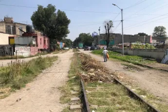
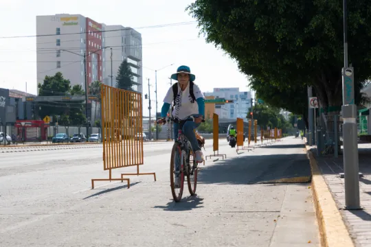
Because of recent deindustrialization, parts of the area that are well-located now lie vacant or underutilized. There is lots of air and noise pollution in the area as the Periférico - the 12-lane highway connecting Mexico City - runs right through it. This also makes the area very reliant on cars as the provision for walking and cycling is poor. The small vans used for public transport only add to the congestion, but are one of the principal transport modes used by the population due to their affordability. The River Hondo is also polluted and flood-prone, leaving the settlements that have been built on the riverbanks vulnerable and the water quality poor. The area also experiences heat islands and is at risk of subsidence. The Urban Lab aims to transform the area and tackle these issues through an urban regeneration project.
The Urban Lab brought together diverse stakeholders, including government authorities, civil society organizations, academia and the private sector.
Following initial analysis of documentation by the team at WRI Mexico, the Lab enabled the convened stakeholders with different knowledge, backgrounds and experiences to feed into the process. They discussed and identified the problems and opportunities within the area. Four key themes were identified to shape the process:
1) Environmental
2) Urban planning and housing
3) Mobility
4) Public services.
Participants worked to understand and map where each issue was particularly problematic and using geospatial analysis with participatory mapping, identified the ‘urban transformation polygon’ to determine the geographical area of focus.
The urban transformation polygon of 241 was identified based on the following criteria:
- Area with the highest concentration of challenges and opportunities identified in the participatory mapping with the lab members
- Area with the highest intensity of heat islands
- Proximity to the Hondo River in an area of influence of 2km
- Maximum distance of 2km to make it walkable
- Delimitation based on existing main and/or continuous roads
- Opportunities for aligning with urban projects happening in the local/municipal context
The polygon was refined and surveyed during the process.
Once the area had been approved and established, Lab participants emphasized the importance of focusing the strategy on the emissions that most contribute to climate change in the area - in this case transport and construction. They also identified the need to update instruments that the municipality had already developed to address climate change - namely the Program of Action Climate of the Municipality of Naucalpan de Juárez 2013-2023 (PACMUNA, 2014), and situated the transformation project in the context of this policy landscape.
The fieldwork of the polygon was undertaken as an important step in developing and defining the collective vision for the area. The resulting joint vision focused on decarbonization, nature-based solutions, addressing water pollution, promoting active mobility and transforming public spaces within that area to deliver reduced emissions, improve road safety and more equality among Naucalpan’s citizens.
The collective vision defined by Urban Lab members is that by 2030, the area should be transformed into an orderly, safe and sustainable district with mixed land use. It would have energy-efficient buildings and comprehensive waste management, as well as being an area with blue-green infrastructure integrated in public spaces. Furthermore, stakeholders aim for sustainable road and transport planning. Lastly, the Hondo River would be healthy and clean.
An action plan to deliver on the vision was co-created across six workshops, field visits and capacity-building sessions with issues of interest for Urban Lab members.

